Marine weather forecasting is the process by whichmarinersand meteorological organizations have attempted toforecast future weather conditionsover theEarth'soceans. Mariners have had rules of thumb regarding the navigation aroundtropical cyclonesfor many years, dividing a storm into halves and sailing through the normally weaker and more navigable half of their circulation.
Thewindis the driving force of weather at sea, as wind generates localwind waves, longocean swells, and its flow around the subtropical ridgehelps maintain warm water currents such as theGulf Stream. The importance of weather over the ocean during World War IIled to delayed or secret weather reports, in order to maintain a competitive advantage.Weather shipswere established by various nations during World War II for forecasting purposes, and were maintained through 1985 to help with transoceanic plane navigation.
Voluntary observations from ships,weather buoys,weather satellites, andnumerical weather predictionhave been used to diagnose and help forecast weather over the Earth's ocean areas. Since the 1960s,numerical weather prediction's role over the Earth's seas has taken a greater role in the forecast process. Weather elements such assea state, surface winds,tidelevels, andsea surface temperatureare tackled by organizations tasked with forecasting weather over open oceans and seas. Currently, theJapan Meteorological Agency, theUnited StatesNational Weather Service, and theUnited KingdomMet Officecreate marine weather forecasts for theNorthern Hemisphere.
Tropical cyclone avoidance
The dangerous semicircle is the upper-right corner, with the arrow marking the direction of motion of a Northern Hemisphere storm.
Mariners have a way to safely navigate around tropical cyclones. They split tropical cyclones in two, based on their direction of motion, and maneuver to avoid the right segment of the cyclone in the Northern Hemisphere (the left in the Southern Hemisphere). Sailors term the right side the dangerous semicircle since the heaviest rain and strongest winds and seas were located in this half of the storm, as the cyclone's translation speed and its rotational wind are additive. The other half of the tropical cyclone is called the navigable semicircle since weather conditions are lessened (subtractive) in this portion of the storm. The rules of thumb for ship travel when a tropical cyclone is in their vicinity are to avoid them if at all possible and do not cross their forecast path (crossing the T). Those traveling through the dangerous semicircle are advised to keep to the true wind on the starboard bow and make as much headway as possible. Ships moving through the navigable semicircle are advised to keep the true wind on the starboard quarter while making as much headway as possible.
The 1-2-3 rule (mariners' 1-2-3 rule or danger area) is a guideline commonly taught to mariners for severe storm (specifically hurricane and tropical storm) tracking and prediction. It refers to the rounded long-term National Hurricane Center forecast errors of 100-200-300nautical miles at 24-48-72 hours, respectively. However, these errors have decreased to near 50-100-150 as NHC forecasters become more accurate with tropical cyclone track forecasting. The "danger area" to be avoided is constructed by expanding the forecast path by a radius equal to the respective hundreds of miles plus the forecast wind radii (size of the storm at those hours).
Utility
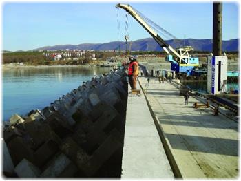
Commercial and recreational use of waterways can be limited significantly by wind direction and speed, wave periodicity and heights, tides, and precipitation. These factors can each influence the safety of marine transit. Consequently, a variety of codes have been established to efficiently transmit detailed marine weather forecasts to vessel pilots via radio, for example the MAFOR (marine forecast). Typical weather forecasts can be received at sea through the use of RTTY, Navtex and Radiofax.
Exercise 2. Make a list of recommendations how to avoid cyclones at sea
Exercise 3. Translate the text about the Beaufort Scale. Make your own active vocabulary
Beaufort Wind Scale
Please note: Beaufort scale numbers and descriptive terms such as 'near gale', 'strong gale' and 'violent storm' are not normally used in Bureau of Meteorology communications or forecasts.
| Beaufort scale number
| Descriptive term
| Units in km/h
| Units in knots
| Description on Land
| Description at Sea
|
|
| Calm
|
|
| Smoke rises vertically
| Sea like a mirror.
|
| 1-3
| Light winds
| 19 km/h or less
| 10 knots or less
| Wind felt on face; leaves rustle; ordinary vanes moved by wind.
| Small wavelets, ripples formed but do not break: A glassy appearance maintained.
|
|
| Moderate winds
| 20 - 29 km/h
| 11-16 knots
| Raises dust and loose paper; small branches are moved.
| Small waves - becoming longer; fairly frequent white horses.
|
|
| Fresh winds
| 30 - 39 km/h
| 17-21 knots
| Small trees in leaf begin to sway; crested wavelets form on inland waters
| Moderate waves, taking a more pronounced long form; many white horses are formed - a chance of some spray
|
|
| Strong winds
| 40 - 50 km/h
| 22-27 knots
| Large branches in motion; whistling heard in telephone wires; umbrellas used with difficulty.
| Large waves begin to form; the white foam crests are more extensive with probably some spray
|
|
| Near gale
| 51 - 62 km/h
| 28-33 knots
| Whole trees in motion; inconvenience felt when walking against wind.
| Sea heaps up and white foam from breaking waves begins to be blown in streaks along direction of wind.
|
|
| Gale
| 63 - 75 km/h
| 34-40 knots
| Twigs break off trees; progress generally impeded.
| Moderately high waves of greater length; edges of crests begin to break into spindrift; foam is blown in well-marked streaks along the direction of the wind.
|
|
| Strong gale
| 76 - 87 km/h
| 41-47 knots
| Slight structural damage occurs -roofing dislodged; larger branches break off.
| High waves; dense streaks of foam; crests of waves begin to topple, tumble and roll over; spray may affect visibility.
|
|
| Storm
| 88 - 102 km/h
| 48-55 knots
| Seldom experienced inland; trees uprooted; considerable structural damage.
| Very high waves with long overhanging crests; the resulting foam in great patches is blown in dense white streaks; the surface of the sea takes on a white appearance; the tumbling of the sea becomes heavy with visibility affected.
|
|
| Violent storm
| 103 -117 km/h
| 56-63 knots
| Very rarely experienced - widespread damage
| Exceptionally high waves; small and medium sized ships occasionally lost from view behind waves; the sea is completely covered with long white patches of foam; the edges of wave crests are blown into froth.
|
| 12+
| Hurricane
| 118 km/h or more
| 64 knots or more
| Very rarely experienced - widespread damage
| The air is filled with foam and spray. Sea completely white with driving spray; visibility very seriously affected
|