For.
3
indicates to the pilot that a manually selected heading is being flown.
4
indicates that the pilot has made a manual track selection.
Вопрос 290
Benefits of Area Navigation include:
1) Pilot choice of vertical and horizontal separations.
2) Reduction in fuel and flight time.
3) No radio contact within RNAV airspace.
4) Reduction in the number of ground navigation facilities
5) Shorter flight distance
The combination regrouping all the correct statements is:
Shorter flight distance
Ответы
1
3, 4,5
2
1,2,4
3
2,4,5
4
1,2, 4,5
Вопрос 291
Apart from radials and distances from VOR/DME stations, what information is required by the VOR/DME Area Navigation computer
in order to calculate the wind?
Ответы
1
Vertical speed from the air data computer.
2
True airspeed from the air data computer.
3
Heading from the aircraft compass system and true airspeed from the air data computer.
4
Heading from the aircraft compass system.
Вопрос 292
Under EASA regulations color code rules for EFIS displays, the recommended color for the selected data and values is?
Ответы
1
yellow
2
Green
3
white
4
magenta
Вопрос 293
Refer to figure 062-10.
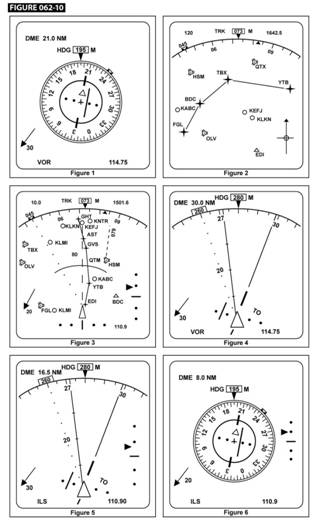
What wind velocity is indicated in display 4?
Ответы
1
285°М / 20 kts
2
030°М / 20 kts
3
320°М / 30 kts
4
105°М / 20 kts
Вопрос 294
FMS cross track (XTK) is:
Ответы
1
The abeam distance error, to the left or right from the desired flight plan leg to the aircraft position.
2
the distance error between the FMS computed position and the GPS computed position.
3
the distance error between the FMS computed position and the IRS computed position.
4
the angular distance error, to the left or right from the desired track (DTK) to the aircraft track (TK).
Вопрос 295
Which one of the following lists information given by a basic VOR/DME-based Area Navigation System when tracking inbound to a
phantom waypoint?
Ответы
1
True airspeed; drift angle.
2
Aircraft position in latitude and longitude.
3
Wind velocity.
4
Crosstrack distance; Distance to Go.
Вопрос 296
Output from which of the following combination of navigational sources provide enough information to the RNAV-equipment to
calculate the wind vector?
Ответы
1
Inertial Reference System and Air Data Computer.
2
Global Positioning System and Compass System.
3
Compass system and Inertial Reference System.
4
Inertial Reference System and Global Positioning System.
Вопрос 297
Which of the following lists information required to input a waypoint or Phantom Station into a basic VOR/DME-based Area
Navigation System?
Ответы
1
Radial and distance from a VOR/DME to the waypoint or Phantom Station.
2
Radials from a minimum of two VORs to the waypoint or Phantom Station.
3
Magnetic track and distance from the aircraft to the waypoint or Phantom Station.
4
Magnetic track and distance to a VOR/DME from the waypoint or Phantom Station.
Вопрос 298
Refer to figure 062-10.

Which of the figures depicts an EFIS display in Expanded (EXP) VOR/ILS mode with an ILS frequency selected?
Ответы
1
Figure 3.
2
Figure 2.
3
Figure 6.
4
Figure 5.
Вопрос 299
Refer to figure 062-10.
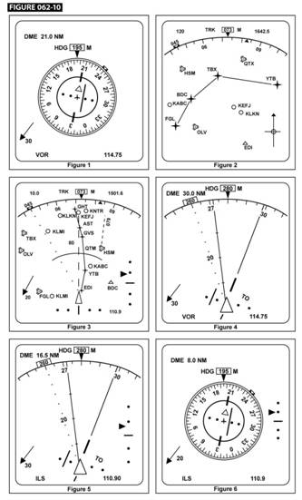
Which of the figures depicts an EFIS display in the Expanded (EXP) VOR/ILS mode with a VOR frequency selected?
Ответы
1
Figure 6.
2
Figure 4.
3
Figure 1.
4
Figure 5.
Вопрос 300
The FMS (Flight Management System) navigation database typically includes the following data:
1) Airport reference data.
2) Nav aid frequencies.
3) Company routes.
4) АТС frequencies.
The combination regrouping all the correct statements is:
Ответы
1
1,2, 3,4
2
1,3,4
3
1,3
4
1,2,3
Вопрос 301
Refer to figure 062-10.

The track from BDC to YTB in display 2
Ответы
1
097° (Т)
2
170° (М)
3
45° (Т)
4
140°(М)
Вопрос 302
On a 5-dot HSI when using RNAV system in the approach mode (APR RNAV) what does a deviation of one dot indicate?
Ответы
1
0,5 NM from desired track
2
1 NM from desired track
3
NM from desired track
4
2 NM from desired track
Вопрос 303
3D RNAV fixing provides:
Ответы
1
Horizontal, vertical profile and time guidance.
2
2D RNAV plus time guidance.
3
2D RNAV plus speed control.
4