Вопрос 304
Example of a self contained RNAV system is
Ответы
1
INS
2
DME/DME
3
VOR/DME
4
GPS
Вопрос 305
Refer to figure 062-10.
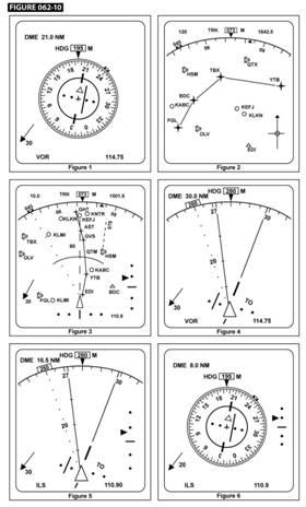
The object followed by the letters "HSM" indicates in display 3:
Ответы
1
a designated alternate airport.
2
the destination airport.
3
an off-route airport.
4
An off-route VOR/DME.
Вопрос 306
Refer to figure 062-02.
Which of the distances indicated will be shown on a basic VOR/DME-based Area Navigation Equipment when using a "Phantom
Station"?
Ответы
1
11 NM
2
10 NM
3
21 NM
4
NM
Вопрос 307
Which of the following lists the first three pages of the FMC/CDU normally used to enter data on initial start-up of the B737-400
Electronic Flight Instrument System?
Ответы
1
IDENT - POS INIT - RTE.
2
POSINIT-RTE-DEPARTURE.
3
POS INIT-RTE-IDENT.
4
IDENT-RTE-DEPARTURE.
Вопрос 308
A full-scale deviation on a 5-dot CDI when using RNAV system in the approach mode represents a deviation from the desired track
of:
Ответы
1
NM.
2
5 NM.
3
2 % NM.
4
1 NM.
Вопрос 309
Refer to figure 062-10.
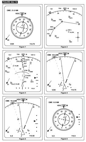
What is the value of the heading shown on display 6?
Ответы
1
240°
2
205°
3
195°
4
015°
Вопрос 310
What is the deviation per dot on the HSI when using a 2-dot HSI RNAV system in the EN-ROUTE (ENR) mode?
Ответы
1
2 NM from desired track.
2
5 NM from desired track.
3
10 NM from desired track.
4
1 NM from desired track.
Вопрос 311
According to EASA regulations, for what type of EFIS message is the colour RED used?
Ответы
1
Flight envelope, system limits, engaged mode.
2
Warnings, cautions, abnormal sources.
3
Cautions, abnormal sources, engaged mode.
4
Warnings, flight envelope, system limits.
Вопрос 312
How long does it take a NAVSTAR GPS satellite to orbit the earth?
Ответы
1
Approximately 24 hours (one sidereal day).
2
12 days.
3
365 days because the satellites are located in a geostationary orbit.
4
Approximately 12 hours (1/2 of a sidereal day).
Вопрос 313
How many operational satellites are required for Full Operational Capability (FOC) of the satellite navigation
system NAVSTAR GPS?
Ответы
1
30
2
18
3
12
4
24
Вопрос 314
Type of satellite navigation system NAVSTAR/GPS receiver is most suitable for use on board an aircraft:
Ответы
1
Any hand held type.
2
Multichannel.
3
Sequential.
4
Multiplex.
Вопрос 315
The system capable of "on the ground" measuring the signal errors transmitted by GNSS satellites and relaying
the measured errors to the user for receiver correction is?
Ответы
1
ABAS
2
SBAS
3
GBAS
4
TBAS
Вопрос 316
Which of the following statements about the accuracy that can be obtained with the differential technique (D-GPS)
of the satellite navigation system NAVSTAR GPS is correct?
Ответы
1
The nearer a receiver is situated to a D-GPS ground station, the more accurate the position fix.
2
The increase in accuracy of position fixes is independent of the receiver position in relation to a D-GPS ground station.
3
Only D-GPS allows position fixes accurate enough for Non Precision Approaches.
4
A D-GPS receiver can detect and correct for SA providing a more accurate position fix.
Вопрос 317
When a GPS receiver is using altitude as an augmentation to RAIM:
Ответы
1
better correction for ionospheric delay will be available.
2
the failure reporting time will be reduced.
3
the accuracy of displaced position will not be affected.
4
The number of satellites to perform RAIM function can be reduced by one.
Вопрос 318
Orbital planes of the satellite navigation system NAVSTAR GPS are:
Ответы
1
inclined 55° to the equatorial plane.
2
inclined 55° to the earth axis.
3
inclined 90° to the equatorial plane.
4
parallel to the equatorial plane.
Вопрос 319
In what type of nominal orbit are NAVSTAR GPS satellites placed?
Ответы
1
Elliptical
2
Nearly circular
3
Geo-stationary
4
Pole to pole
Вопрос 320
Which statement about the pseudo range corrections determined by the SBAS is correct?
Ответы
1
The pseudo range corrections are determined by a station network on the ground for satellites; the same correction is sent to the users.
2
In a SBAS the pseudo range corrections are determined by geostationary satellites and the satellites for the users by a network of ground stations.
3